Have you ever wondered if that fence line or new pool sits exactly where it should? In Denton County, a property survey gives you clarity on where boundaries, easements, and improvements actually sit on the ground. Whether you are buying, selling, or planning a project, understanding survey basics can prevent delays and surprises at closing. In this guide, you will learn what a survey shows, when lenders and title companies require one, how a T-47 affidavit works, what it costs locally, and a simple checklist to review a survey with confidence. Let’s dive in.
Survey basics in Denton County
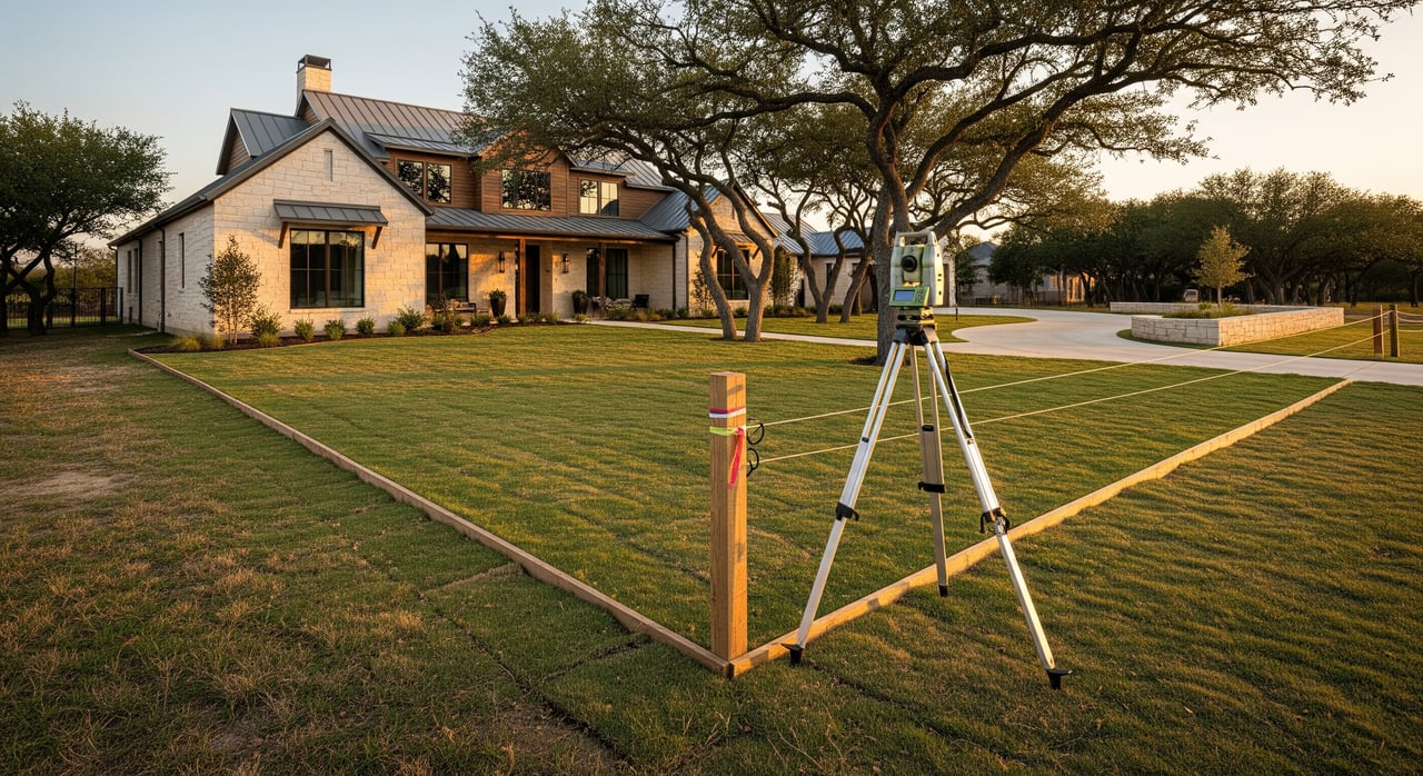
A property survey is a professional map of your land and visible improvements relative to recorded boundary lines. Buyers, lenders, title companies, and cities use surveys to verify locations and check for conflicts. In Denton County and across DFW, surveys help confirm that houses, fences, driveways, and pools sit within the boundary and outside recorded easements.
Common residential survey types include boundary surveys, improvement or mortgage surveys for closings, and ALTA/NSPS surveys for complex or commercial needs. Most single-family transactions rely on a boundary or improvement survey that shows the lot lines, visible improvements, and recorded easements.
Texas survey: what it shows
A typical Texas residential survey will show:
- Property lines with bearings and distances, and the calculated area.
- Monuments and markers used to establish the boundaries.
- Existing visible improvements, such as the home, garage, pool, driveway, fences, decks, sheds, wells, or septic.
- Recorded easements and rights-of-way that affect the parcel.
- Encroachments, such as a neighbor’s fence crossing the line or an owner’s driveway over a boundary.
- Building setback or restriction lines if recorded.
- Surveyor’s certification, seal, signature, effective date, and notes.
Always check the survey date and the surveyor’s certification. A survey is a point-in-time snapshot, so later changes will not appear unless the survey is updated.
What surveys do not show
Surveys are powerful, but they have limits. They typically do not:
- Locate all underground utilities unless a specific locate is provided.
- Establish ownership or reveal title defects; a survey is not a title search.
- Show unrecorded agreements or easements unless visible or disclosed.
- Confirm zoning compliance, permits, or interior conditions.
- Prove mineral ownership or building code compliance.
Use the survey together with title work and municipal records to get the full picture.
When surveys are required locally
In Denton County, several parties may require a survey:
- Lenders often require a survey or survey exception removal to underwrite a loan.
- Title companies use surveys to set title insurance exceptions and identify issues that must be addressed.
- Buyers request surveys for peace of mind or when boundary questions exist.
- Cities may require a current survey or site plan for permitting.
Local practice commonly allows an existing survey if it is recent and nothing has changed on the property. Acceptance varies by lender and title company, and you can often negotiate who pays for a new survey if one is needed.
New survey or T-47 affidavit?
When an older but accurate survey exists, many Denton County transactions rely on a seller’s affidavit of no change, often called a T-47 by title companies.
How a T-47 works
A T-47 is a signed statement that no visible changes have occurred since the date of the existing survey. Title companies use it to rely on the older survey instead of ordering a new one. Acceptance is at the title company’s discretion and may depend on lender requirements and the policy or endorsements requested.
When to order a new survey
Order a new survey if you see new or relocated improvements, suspect an encroachment, or the survey is quite old. Also order new if lots were split or replatted, adjacent parcels changed, or your lender requires an ALTA/NSPS standard. When in doubt, a fresh survey reduces risk and delays.
Updates and supplemental checks
Some surveyors offer limited updates tied to a prior survey, while others will perform a full re-survey with new field work and certification. Acceptability and cost vary, so confirm with the title company and lender before you order.
Costs and timing in Denton County
- Typical cost for a single-family lot: about 300 to 900 dollars for a standard residential boundary or improvement survey.
- Larger or complex properties, or ALTA/NSPS needs: 1,000 dollars or more.
- Turnaround: about 3 to 14 business days, depending on the surveyor’s workload, site complexity, and research.
Build time into your contract timeline. Do not wait until the last minute if there is any boundary or easement concern.
How to review a survey
Use this simple checklist to catch issues early and keep closing on track.
Before you go under contract
- Ask the seller if a recent survey exists and request a copy early.
- Confirm lender requirements for survey type if financing is involved.
- If the property is platted, get the recorded plat to compare easements and building lines.
When you receive a survey
- Verify the legal description matches the deed and contract.
- Check the survey date and confirm the surveyor’s stamp and signature.
- Note any referenced recorded instruments and confirm they match the title commitment.
- Locate all easements and their widths; check for improvements within easements.
- Look for encroachments, including fences or driveways crossing boundaries.
- Check setback or building restriction lines for conformity to your intended use.
- Review flood zone notes and confirm status with FEMA maps if needed.
- Ask if any visible changes have been made since the survey date.
- Confirm with the title company whether they will accept the existing survey or require a new survey or affidavit.
Questions to ask
- Seller: When was the last change to fences, driveways, pools, sheds, or additions? Do you have a prior survey?
- Title company: Will you accept this survey as-is? Will you accept a no-change affidavit or require a new survey? What survey-related exceptions will appear on the commitment?
- Surveyor: Will this survey meet my lender’s requirements? Can you update it, and what is the cost and timeline?
Decision points
- If the survey is recent and no visible changes exist, a T-47 may be acceptable. Confirm with lender and title.
- If changes or ambiguities exist, order a new survey well before closing.
- If a boundary dispute appears, consult a real estate attorney. A surveyor can document the issue, but title disputes require legal solutions.
What to do if you find an issue
Minor encroachments, such as a fence slightly over a lot line, are often handled with a written agreement or scheduled as a permitted title exception. Significant encroachments, like a structure over the line or a building within an easement, may require removal, a replat, an easement agreement, or a price adjustment. Title companies may delay or condition closing until the issue is resolved to their satisfaction and the lender’s.
Local records and resources
When you need more information for a Denton County property, check these sources:
- Denton County Clerk for recorded plats, deeds, easements, and restrictive covenants.
- Denton County Appraisal District for parcel data and legal descriptions used for taxation.
- Denton County GIS mapping portal for parcel maps and flood overlays.
- City permitting departments, including the City of Denton and neighboring municipalities, for permit histories and platting.
- FEMA flood insurance rate maps for flood zone status.
- Texas Board of Professional Land Surveying to verify surveyor licensing and standards.
- Texas Land Title Association for commonly used title forms and practices, including affidavits used by title companies.
Move forward with confidence
A clear survey keeps your transaction on track and protects your plans for the property. Start early, confirm lender and title requirements, and use the checklist above to review what you receive. If questions arise about fences, easements, or encroachments, get a licensed Texas surveyor’s input and coordinate with your title officer.
If you want hands-on guidance across Highland Village, Denton, and the north DFW suburbs, reach out to Paula Bradley. With local experience and calm, white-glove service, you will have the clarity you need from contract to closing.
FAQs
What does a residential property survey include in Denton County?
- It typically shows boundary lines with measurements, visible improvements, recorded easements, encroachments, and the surveyor’s certification, seal, and date.
When will my lender require a new survey in Denton County?
- Many lenders require a current survey or acceptance of an older one with a no-change affidavit; the lender’s underwriting standards ultimately control what is acceptable.
How does the Texas T-47 affidavit of no change work for a seller?
- A seller signs that no visible changes occurred since the existing survey date, allowing the title company to rely on it, but acceptance is at the title and lender’s discretion.
How much does a Denton County residential survey cost and how long does it take?
- Standard residential surveys often cost about 300 to 900 dollars and take about 3 to 14 business days; complex or ALTA needs may exceed 1,000 dollars and take longer.
What if my survey shows a fence or structure over the property line?
- Minor issues may be handled with an agreement or a permitted title exception, while significant encroachments may require removal, a new easement, a replat, or legal counsel.
Do I need an ALTA/NSPS survey for a single-family home in Denton?
- Most home purchases use a residential boundary or improvement survey; ALTA/NSPS standards are typically reserved for commercial or complex lending needs.